Look closely at the evidence
Reading the photographs.
What made a collection of roads, tents and vehicles look like a missile base? Examine two genuine reconnaissance photographs, with a guide to the features identified on the original briefing boards.
01 / High-altitude reconnaissance
San Cristóbal, 14 October.
This U-2 photograph records Site 1 in western Cuba. It belongs to the set of annotated reconnaissance images used to brief President Kennedy on 16 October. The labels are an intelligence interpretation of the photograph, not words that existed on the ground.
Sources for this passage: [1]Select a blue number to find its explanation. Turn the numbered guide off to inspect the original briefing board, or open the full image to enlarge it.
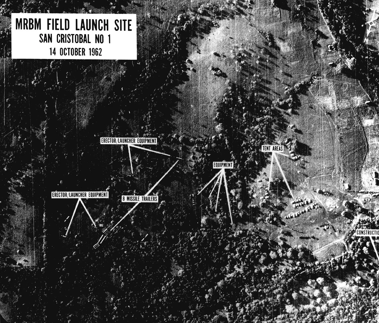
San Cristóbal, 14 October 1962. This annotated reconnaissance photograph was among the images shown to President Kennedy on 16 October.
US government reconnaissance photograph; John F. Kennedy Presidential Library and Museum, via Wikimedia Commons. Source record · Public domain — US government work.
Blue numbers are this website’s reading guide. The original photographic labels are retained. No features have been generated or added to the photograph.
Missile trailers
The briefing board identifies eight missile trailers. Analysts used the dimensions and arrangement of equipment to identify a deployment; this is not a photograph of eight missiles standing upright, ready to fire.
Erectors and launch equipment
The labels point to equipment used to handle and erect the missiles. Read those objects together with the transporters and support vehicles, rather than treating one indistinct shape as proof on its own.
The supporting equipment
A missile unit needed more than the missile itself. The equipment group is part of the pattern that made the location recognisable as a military deployment.
Tent areas
The marked tent areas help show the scale and layout of the encampment. Tents are evidence of activity at the site; they do not reveal who was inside or whether a launch order had been issued.
02 / A closer, oblique view
The same site area, 23 October.
A US Navy low-level photograph provides a different angle on San Cristóbal Site 1. The National Security Archive identifies it with the mission led by Commander William Ecker. The image itself is dated 23 October; it should not be mistaken for the 14 October U-2 discovery photograph.
Sources for this passage: [2]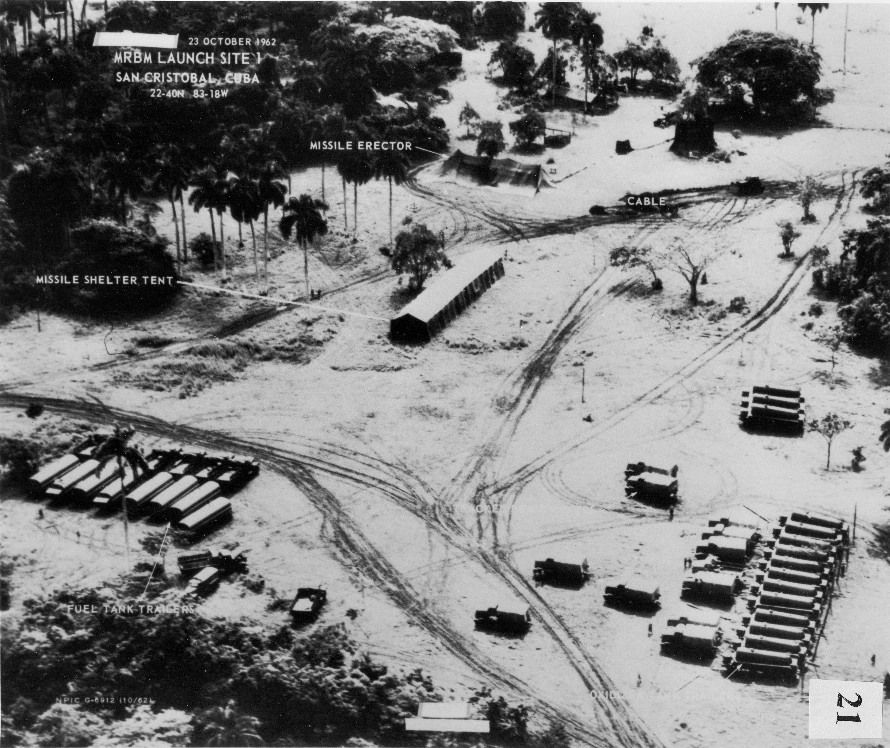


San Cristóbal Site 1, 23 October 1962: a US Navy low-level reconnaissance photograph. Original briefing-board annotations retained.
US Navy reconnaissance photograph / US government briefing board. Dino A. Brugioni collection, National Security Archive, image 21. Source record · Public domain in the United States — official US government work.
Blue numbers are this website’s reading guide. The original photographic labels are retained. No features have been generated or added to the photograph.
The covered erector
The original label identifies the missile erector beneath a cover near the upper centre. Covering equipment did not erase the surrounding site layout.
Missile shelter tent
The long shelter is much easier to distinguish in this oblique, low-level view. The tent’s exterior is visible; its contents cannot be read directly from this photograph.
Fuel tank trailers
The briefing board identifies the cluster at lower left as fuel tank trailers. Support vehicles were important clues to the type and purpose of the installation.
Cable and ground activity
The original cable label and the visible vehicle tracks show how equipment was connected and moved around the site. They help explain the installation, without proving its exact readiness at the instant of exposure.
Evidence, then interpretation
What can the camera tell us?
Visible equipment is a starting point
Photographs show objects and their relationships: a transporter beside a shelter, handling equipment in a cleared area, or a network of support vehicles. The numbered guide follows features already identified on these historical briefing boards; it is not a new technical analysis of the negatives.
Readiness required an assessment
Intelligence analysts combined photography with other information. Their 19 October evaluation distinguished existing medium-range deployments from longer-range installations still under construction. A photograph alone could not settle every question about warheads, readiness or command authority.
Sources for this passage: [3]Compare sources, dates and viewpoints
A later photograph can record further construction, camouflage or repositioning. It can also make an old feature easier to see simply because the aircraft flew at a different height or angle. These two views should therefore be compared as evidence from different dates and perspectives, not a perfectly aligned before-and-after pair.
Read how the missiles were discovered · The U-2 · The RF-8 Crusader
Sources for this page3 references
Numbers refer to the passages above. Open a title to read the source, or use a return link to go back to its citation.
- National Archives: San Cristóbal reconnaissance photograph, 14 October 1962, PX1966-020-007↩ Back to text
- National Security Archive, reconnaissance photographs 15–24: original briefing boards, 14–23 October 1962↩ Back to text
- FRUS supplement, document 342: joint evaluation of the Soviet missile threat, 19 October 1962↩ Back to text